
|
|
|
For more information see: Corné Kreemer's GSRM pages. THIS SITE NO LONGER MAINTAINED AND HERE FOR ARCHIVAL PURPOSES.DataFor the current GSRM, 6739 velocities were derived from position time-series obtained from the analysis of RINEX data that was either freely available or made available to us specifically for this project. All but 34 of these velocities were used in the modeling. We added 15,710 velocities from 233 studies in the published literature (or from personal communications) to achieve a grand total of 22,415 velocities at 18,356 unique locations used in the modeling. Of all velocities, 17,567 are in plate boundary zones (as defined by us) and the remaining 4848 velocities are for points on, predefined, rigid tectonic plates. UNR GPS AnalysisWe use GIPSY-OASIS II software for the data analysis package from the Jet Propulsion Laboratory (JPL). Station coordinates were estimated every 24 hours using the Precise Point Positioning method [Zumberge et al.,1997]. Ionosphere-free combinations of carrier phase and pseudorange were processed every 5 minutes. The observable model includes ocean tidal loading and companion tides [Scherneck,1991] using the FES2004 ocean tidal model [Lyard et al.,2006], estimation of wet zenith troposphere and two gradient parameters as a random walk process [Bar-Sever et al.,1998] using the GMF mapping function [Boehm et al.,2006], and antenna calibrations for ground receivers and satellite transmitters [Schmid et al.,2007], and station clocks estimated as a white-noise process. We applied JPL's single receiver ambiguity resolution [Bertiger et al.,2010], which significantly reduces the scatter in the East component time-series. Satellite orbit and clock parameters were provided by JPL, who determine them in a global fiducial-free analysis using a subset of the available IGS core stations as tracking sites. The fiducial-free daily GPS solutions are aligned to IGS08 [Rebischung et al.,2012] by applying a seven parameter Helmert transformation (3 rotations, 3 translations and a scale component) obtained from JPL [Bertiger et al.,2010]. We consider all data between January 01, 1996, and December 31, 2013, but only derive velocities from time-series that are at least 2.5 years long, so as to best account for seasonal cycles [Blewitt and Lavallée,2002]. In some cases, time-series for (near) collocated stations are concatenated to extend their length and/or to derive a single velocity for two stations that operated consecutively. Because we are interested in capturing the “secular”, or interseismic, velocity, we exclude parts of the time-series that show significant transient motion. These transients are often due to postseismic deformation or slow-slip events (where the excluded part of the time-series is replaced with an offset). In the extreme, the exclusion could be for periods >10 years, sometimes at stations as far as several thousands kilometers from the largest earthquakes [Baek et al.,2012; Tregoning et al.,2013]. We model the time-series as an offset + trend (i.e., velocity) + annual cycle + semi-annual cycle + offsets. Offsets could come from equipment changes, earthquakes, or unknown reasons discovered in the analysis. Some stations only have intermittent data limiting our ability to model the seasonal terms, which could bias the velocity estimate. We therefore apply a damped inversion, which ensures that the amplitude of the seasonal cycles remains at bay in those cases where data is only available for short periods year(s) apart. The velocities uncertainties are not adopted from this inversion, because it is well-known that those are too small due to the time-correlation of the errors. Instead we use the CATS software to calculate velocity uncertainties under the assumption that the error model consists of flicker-noise plus white-noise. We then multiplied the standard deviations with a factor of 2.0 so that the reduced chi-squared for fitting rigid-body rotations to velocities on stable plates is closer to 1.0. Stations for which the time-series indicated rapid subsidence, unexplained transient, or for which the velocities were significantly different than nearby stations, were excluded. We also excluded any station near volcanic activity. For the strain rate modeling we removed 34 velocities for stations within 22 km of the creeping section of the San Andreas Fault . The reason for this that the velocity profile across this fault is a step-function, which causes artifacts in the model, i.e., the spline function that we fit to the data will contain “overshoots” [Kreemer et al.,2012]. Removal of the data points close to the fault allows us to model the step-function as close as possible without creating “overshoots”. Synthesis of Published VelocitiesThe majority of geodetic velocities are derived from campaign-style measurements and are typically published in the literature. In other cases, publications report velocities for CGPS stations for which data is not publicly available. A very small minority of publications also report velocities derived from non-GPS techniques, such as DORIS, VLBI, or trilateration. For several studies did researchers supply us with additional information such as station coordinates or velocities at nearby IGS sites. Six investigators sent us unpublished results. For the first time, we included a handful of velocity estimates from submarine markers, off shore Peru and Japan. We applied the following criteria to decide whether data should be included: a) studies were excluded when the velocity field was entirely based on publicly available data from (semi-)CGPS stations already analyzed for the core solution. b) if study a clearly superseded study b,then only results from study b were used. When in doubt both were included; c) clear outlier velocities were removed, including those affected by volcanic deformation; d) results reflecting postseismic deformation were not included; e) velocities derived from <2.5 year (or sometimes <2 year) time-series were excluded; f) any station that was also excluded from the core solution; g) velocities for 64 stations near the creeping portion of the San Andreas Fault. Next, we performed one large inversion in which we solve for, and apply, a translation rate and rotation rate that would minimize velocity differences at collocated sites (within ~1km) and transform all results into the IGS08 reference frame of our core solution. This is done for all studies simultaneously, because study a may, for example, not have any collocated sites with the core solution, but has them with study b,which does have collocated sites with the core solution. Any velocity for a site collocated with the core solution will be removed, under the assumption that the velocity of the core solution is superior (e.g., it is typically derived from longer time-series and we checked offsets ourselves). At least three collocated sites are needed to solve for a translation and rotation rate. If only two collocated sites are present, we only solve for a rotation rate. To avoid solving for a large translation rate when the geographic footprint is small (in which case there may be a trade-off between translation and rotation rate), we damp the inversion in favor of the rotation parameters. In the few cases where study a mostly supersedes study b,but some velocities from study b are not in study a,we first translate study b onto study a before we perform the global transformation. In those cases do we not duplicate the velocities at the collocated sites. In the end, we included 15,710 velocities from the literature. Together with the core solution, there are 22,415 velocity data at 18,356 unique locations available for the modeling. 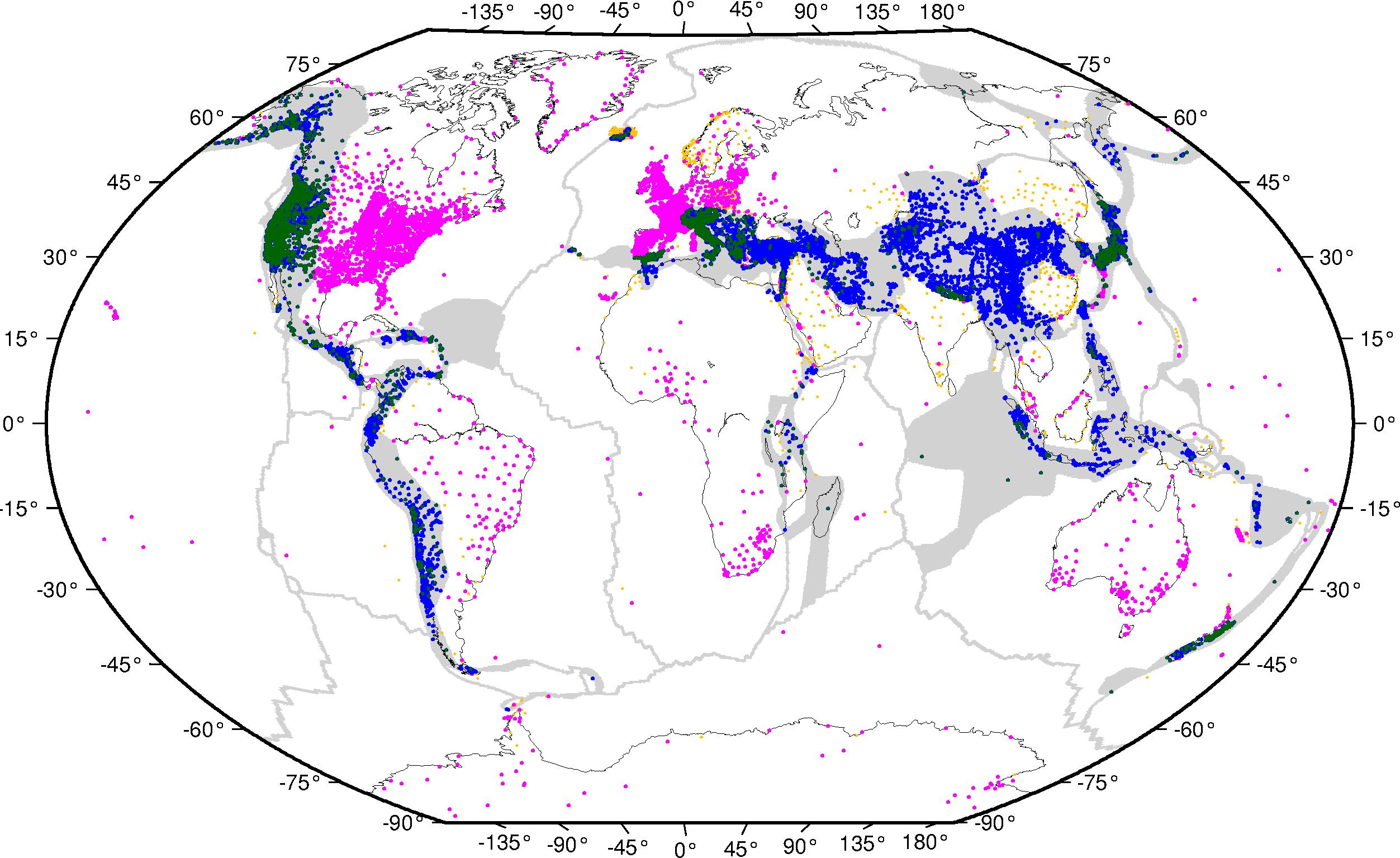
Figure 1. Gray shading is outline of all areas allowed to deform. White areas comprised of 50 assumed rigid plates. Purple and green dots are for GPS stations on rigid plates or in deforming zones, respectively, for which we derived a velocity. Yellow and blue dots are for GPS stations on rigid plates or in deforming zones, respectively, for which we took the velocity from the literature. PlateMotionsOf the 50 plates, 36 angular velocities were estimated from the GPS velocities by this project, 6 were taken from PB2002 [Bird,2003] and 8 were taken from MORVEL [DeMets et al.,2010]. A table with angular velocities relative to the Pacific plate, can be found here. We chose to not use every GPS velocity on each rigid plate to estimate the angular velocities. Typically we would only use the best-behaved, longest running stations from our own analysis. In some cases, there were insufficient stations from our own analysis (or a sufficient number was not well distributed across the plate) to estimate the angular velocity. In those cases we also used velocities from the literature synthesis. In general, we would omit stations near plate boundaries, as those may be affected by elastic strain accumulation. ReferencesBaek, J., Y.-H. Shin, S.-H. Na, N. V. Shestakov, P.-H. Park, and S. Cho (2012), Coseismic and postseismic crustal deformations of the Korean Peninsula caused by the 2011 Mw 9.0 Tohoku earthquake, Japan, from global positioning system data, Terra Nova,24(4), 295–300, https://doi.org/10.1111/j.1365-3121.2012.01062.x. Bar-Sever, Y. E., P. M. Kroger, and J. A. Borjesson (1998), Estimating horizontal gradients of tropospheric path delay with a single GPS receiver, J. Geophys. Res.,103(B3), 5019–5035, https://doi.org/10.1029/97JB03534. Bertiger, W., S. D. Desai, B. Haines, N. Harvey, A. W. Moore, S. Owen, and J. P. Weiss (2010), Single receiver phase ambiguity resolution with GPS data, J Geod,84(5), 327–337, https://doi.org/10.1007/s00190-010-0371-9. Bird, P. (2003), An updated digital model of plate boundaries, Geochemistry, Geophysics, Geosystems,4(3), 1027, https://doi.org/10.1029/2001GC000252. Blewitt, G., and D. Lavallée (2002), Effect of annual signals on geodetic velocity, J. Geophys. Res.,107(B7), B72145, https://doi.org/10.1029/2001JB000570. Boehm, J., A. Niell, P. Tregoning, and H. Schuh (2006), Global Mapping Function (GMF): A new empirical mapping function based on numerical weather model data, Geophys. res. Lett.,33(7), L07304, https://doi.org/10.1029/2005GL025546. DeMets, C., R. G. Gordon, and D. F. Argus (2010), Geologically current plate motions, Geophys. J. Int.,181(1), 1–80, https://doi.org/10.1111/j.1365-246X.2009.04491.x. Gan, W., P. Zhang, Z.-K. Shen, Z. Niu, M. Wang, Y. Wan, D. Zhou, and J. Cheng (2007), Present-day crustal motion within the Tibetan Plateau inferred from GPS measurements, J. Geophys. Res.,112(B8), B08416, https://doi.org/10.1029/2005JB004120. Lyard, F., F. Lefevre, T. Letellier, and O. Francis (2006), Modelling the global ocean tides: modern insights from FES2004, Ocean Dynamics,56(5-6), 394–415, https://doi.org/10.1007/s10236-006-0086-x. Rebischung, P., J. Griffiths, J. Ray, R. Schmid, X. Collilieux, and B. Garayt (2012), IGS08: the IGS realization of ITRF2008, GPS Solut.,16(4), 483–494, https://doi.org/10.1007/s10291-011-0248-2. Scherneck, H.-G. (1991), A parametrized solid earth tide model and ocean tide loading effects for global geodetic baseline measurements, Geophys. J. Int.,106(3), 677–694, https://doi.org/10.1111/j.1365-246X.1991.tb06339.x. Schmid, R., P. Steigenberger, G. Gendt, M. Ge, and M. Rothacher (2007), Generation of a consistent absolute phase-center correction model for GPS receiver and satellite antennas, J. Geod.,81(12), 781–798, https://doi.org/10.1007/s00190-007-0148-y. Shen, Z.-K., C. Zhao, A. Yin, Y. Li, D. D. Jackson, P. Fang, and D. Dong (2000), Contemporary crustal deformation in east Asia constrained by Global Positioning System measurements, J. Geophys. Res.,105(B3), 5721–5734, https://doi.org/10.1029/1999JB900391. Shen, Z.-K., M. Wang, Y. Li, D. D. Jackson, A. Yin, D. Dong, and P. Fang (2001), Crustal deformation along the Altyn Tagh fault system, western China, from GPS, J. Geophys. Res.,106(B12), 30,607–30,621, https://doi.org/10.1029/2001JB000349. Shen, Z.-K., J. Lü, M. Wang, and R. Bürgmann (2005), Contemporary crustal deformation around the southeast borderland of the Tibetan Plateau, J. Geophys. Res.,110(B11), B11409, https://doi.org/10.1029/2004JB003421. Tregoning, P., R. Burgette, S. c. McClusky, S. Lejeune, C. s. Watson, and H. McQueen (2013), A decade of horizontal deformation from great earthquakes, J. Geophys. Res.,in press,https://doi.org/10.1002/jgrb.50154. Wang, Q. et al. (2001), Present-Day Crustal Deformation in China Constrained by Global Positioning System Measurements, Science,294(5542), 574–577, https://doi.org/10.1126/science.1063647. Zhang, P.-Z. et al. (2004), Continuous deformation of the Tibetan Plateau from global positioning system data, Geology,32(9), 809–812, https://doi.org/10.1130/G20554.1. Zumberge, J. F., M. B. Heflin, D. C. Jefferson, M. M. Watkins, and F. H. Webb (1997), Precise point positioning for the efficient and robust analysis of GPS data from large networks, J. Geophys. Res.,102(B3), 5005–5017, https://doi.org/10.1029/96JB03860. Geodetic ReferencesAder, T. et al. (2012), Convergence rate across the Nepal Himalaya and interseismic coupling on the Main Himalayan Thrust: Implications for seismic hazard, J. Geophys. Res., 117, B04403, https://doi.org/201210.1029/2011JB009071. Aktuğ, B., and A. Kılıçoğlu (2006), Recent crustal deformation of İzmir, Western Anatolia and surrounding regions as deduced from repeated GPS measurements and strain field, J. Geodyn., 41(5), 471–484, https://doi.org/10.1016/j.jog.2006.01.004. Aktuğ, B. et al. (2009), Deformation of western Turkey from a combination of permanent and campaign GPS data: Limits to block-like behavior, J. Geophys. Res., 114(B10), B10404, https://doi.org/10.1029/2008JB006000. Aktuğ, B., E. Parmaksız, M. Kurt, O. Lenk, A. Kılıçoğlu, M. A. Gürdal, and S. Özdemir (2013a), Deformation of Central Anatolia: GPS implications, J. Geodyn., 67, 78–96, https://doi.org/10.1016/j.jog.2012.05.008. Aktuğ, B., E. Meherremov, M. Kurt, S. Özdemir, N. Esedov, and O. Lenk (2013b), GPS constraints on the deformation of Azerbaijan and surrounding regions, J. Geodyn., 67, 40–45, https://doi.org/10.1016/j.jog.2012.05.007. Aktuğ, B., U. Dikmen, A. Dogru, and H. Ozener (2013c), Seismicity and strain accumulation around Karliova Triple Junction (Turkey), J. Geodyn., 67, 21–29, https://doi.org/10.1016/j.jog.2012.04.008. Almuselmani, B., F. . Teferle, R. M. Bingley, and T. Moore (2008), New estimates of present-day Arabia plate motion and deformation from a dense GPS network in Saudi Arabia, vol. 89, p. G34A–02. Alvarado, A. et al. (2014), Active tectonics in Quito, Ecuador, assessed by geomorphological studies, GPS data, and crustal seismicity, Tectonics, 33, 67–83, https://doi.org/10.1002/2012TC003224. Alvarado, D., C. DeMets, B. Tikoff, D. Hernández, T. F. Wawrzyniec, C. Pullinger, G. Mattioli, H. L. Turner, M. Rodriguez, and F. Correa-Mora (2011), Forearc motion and deformation between El Salvador and Nicaragua: GPS, seismic, structural, and paleomagnetic observations, Lithosphere, 3(1), 3–21, https://doi.org/10.1130/L108.1. Antonelis, K., D. J. Johnson, M. M. Miller, and R. Palmer (1999), GPS determination of current Pacific–North American plate motion, Geology, 27(4), 299–302, https://doi.org/10.1130/0091-7613(1999)027<0299:GDOCPN>2.3.CO;2. Apel, E. V., R. Bürgmann, G. Steblov, N. Vasilenko, R. King, and A. Prytkov (2006), Independent active microplate tectonics of northeast Asia from GPS velocities and block modeling, Geophys. Res. Lett., 33(11), L11303, https://doi.org/10.1029/2006GL026077. Árnadóttir, T., W. Jiang, K. L. Feigl, H. Geirsson, and E. Sturkell (2006), Kinematic models of plate boundary deformation in southwest Iceland derived from GPS observations, J. Geophys. Res., 111(B7), B07402, https://doi.org/10.1029/2005JB003907. Árnadóttir, T., B. Lund, W. Jiang, H. Geirsson, H. Björnsson, P. Einarsson, and T. Sigurdsson (2009), Glacial rebound and plate spreading: results from the first countrywide GPS observations in Iceland, Geophys. J. Int., 177(2), 691–716, https://doi.org/10.1111/j.1365-246X.2008.04059.x. Ashurkov, S. V., V. A. San’kov, A. I. Miroshnichenko, A. V. Lukhnev, A. P. Sorokin, M. A. Serov, and L. M. Byzov (2011), GPS geodetic constraints on the kinematics of the Amurian Plate, Rus Geol Geophys, 52(2), 239–249, https://doi.org/10.1016/j.rgg.2010.12.017. Aurelio, M. A. (2001), GPS velocities in Mindanao Island, J. Geol. Soc. Philipp., 56, 214–224. Avallone, A., P. Briole, A. M. Agatza-Balodimou, H. Billiris, O. Charade, C. Mitsakaki, A. Nercessian, K. Papazissi, D. Paradissis, and G. Veis (2004), Analysis of eleven years of deformation measured by GPS in the Corinth Rift Laboratory area, Comptes Rendus Geosci., 336(4–5), 301–311, https://doi.org/10.1016/j.crte.2003.12.007. Ayhan, M. E., C. Demir, O. Lenk, A. Kiliçoglu, Y. Altiner, A. A. Barka, S. Ergintav, and H. Özener (2002), Interseismic strain accumulation in the Marmara Sea region, Bull. Seismol. Soc. Am., 92(1), 216–229, https://doi.org/10.1785/0120000818. Bacolcol, T., E. Barrier, T. Duquesnoy, A. Aguilar, R. Jorgio, R. de la Cruz, and M. Lasala (2005), GPS constraints on Philippine Fault slip rate in Masbate Island, central Philippines, J. Geol. Soc. Philipp., 60, 1–7. Banerjee, P., R. Bürgmann, B. Nagarajan, and E. Apel (2008), Intraplate deformation of the Indian subcontinent, Geophys. Res. Lett., 35(18), L18301, https://doi.org/10.1029/2008GL035468. Beavan, J., and J. Haines (2001), Contemporary horizontal velocity and strain rate fields of the Pacific-Australian plate boundary zone through New Zealand, J. Geophys. Res. Solid Earth, 106(B1), 741–770, https://doi.org/10.1029/2000JB900302. Beavan, J. et al. (1999), Crustal deformation during 1994–1998 due to oblique continental collision in the central Southern Alps, New Zealand, and implications for seismic potential of the Alpine fault, J. Geophys. Res., 104(B11), 25233–25255, https://doi.org/10.1029/1999JB900198. Béjar-Pizarro, M., A. Socquet, R. Armijo, D. Carrizo, J. Genrich, and M. Simons (2013), Andean structural control on interseismic coupling in the North Chile subduction zone, Nat. Geosci., 6, 462–467, https://doi.org/10.1038/ngeo1802. Benford, B., C. DeMets, B. Tikoff, P. Williams, L. Brown, and M. Wiggins-Grandison (2012), Seismic hazard along the southern boundary of the Gônave microplate: block modelling of GPS velocities from Jamaica and nearby islands, northern Caribbean, Geophys. J. Int., 190(1), 59–74, https://doi.org/10.1111/j.1365-246X.2012.05493.x. Bennett, R.A. (2013), Personal Communication. Bennett, R. A. et al. (2012), Syn-convergent extension observed using the RETREAT GPS network, northern Apennines, Italy, J. Geophys. Res., 117(B4), B04408, https://doi.org/10.1029/2011JB008744. Le Beon, M. L., Y. Klinger, A. Q. Amrat, A. Agnon, L. Dorbath, G. Baer, J.-C. Ruegg, O. Charade, and O. Mayyas (2008), Slip rate and locking depth from GPS profiles across the southern Dead Sea Transform, J. Geophys. Res., 113(B11), B11403, https://doi.org/10.1029/2007JB005280. Bergeot, N., M. N. Bouin, M. Diament, B. Pelletier, M. Régnier, S. Calmant, and V. Ballu (2009), Horizontal and vertical interseismic velocity fields in the Vanuatu subduction zone from GPS measurements: Evidence for a central Vanuatu locked zone, J. Geophys. Res., 114(B6), B06405, https://doi.org/10.1029/2007JB005249. Bettinelli, P., J.-P. Avouac, M. Flouzat, F. Jouanne, L. Bollinger, P. Willis, and G. Chitrakar (2006), Plate Motion of India and Interseismic Strain in the Nepal Himalaya from GPS and DORIS Measurements, J. Geod., 80(8), 567–589, https://doi.org/10.1007/s00190-006-0030-3. Bock, Y., L. Prawirodirdjo, J. F. Genrich, C. W. Stevens, R. McCaffrey, C. Subarya, S. S. O. Puntodewo, and E. Calais (2003), Crustal motion in Indonesia from Global Positioning System measurements, J. Geophys. Res., 108(B8), 2367, https://doi.org/10.1029/2001JB000324. Bogusz, J. (2012), Personal Communication. Brooks, B. A., M. Bevis, R. S. Jr, E. Kendrick, R. Manceda, E. Lauría, R. Maturana, and M. Araujo (2003), Crustal motion in the Southern Andes (26°–36°S): Do the Andes behave like a microplate?, Geochem. Geophys. Geosystems, 4(10), 1085, https://doi.org/10.1029/2003GC000505. Brooks, B. A. et al. (2011), Orogenic-wedge deformation and potential for great earthquakes in the central Andean backarc, Nat. Geosci., 4(6), 380–383, https://doi.org/10.1038/ngeo1143. Calais, E., L. Dong, M. Wang, Z. Shen, and M. Vergnolle (2006), Continental deformation in Asia from a combined GPS solution, Geophys. Res. Lett., 33(24), L24319, https://doi.org/10.1029/2006GL028433. Calais, E., A. Freed, G. Mattioli, F. Amelung, S. Jónsson, P. Jansma, S.-H. Hong, T. Dixon, C. Prépetit, and R. Momplaisir (2010), Transpressional rupture of an unmapped fault during the 2010 Haiti earthquake, Nat. Geosci., 3(11), 794–799, https://doi.org/10.1038/ngeo992. Calmant, S., B. Pelletier, P. Lebellegard, M. Bevis, F. W. Taylor, and D. A. Phillips (2003), New insights on the tectonics along the New Hebrides subduction zone based on GPS results, J. Geophys. Res., 108(B6), 2319, https://doi.org/10.1029/2001JB000644. Caporali, A. et al. (2009), Surface kinematics in the Alpine–Carpathian–Dinaric and Balkan region inferred from a new multi-network GPS combination solution, Tectonophysics, 474(1–2), 295–321, https://doi.org/10.1016/j.tecto.2009.04.035. Catherine, J. K., V. K. Gahalaut, N. Srinivas, S. Kumar, and B. Nagarajan (2014), Evidence of Strain Accumulation in the Andaman Region for the Giant 2004 Sumatra Andaman Earthquake, Bull. Seismol. Soc. Am., 104(1), 587–591, https://doi.org/10.1785/0120130141. Cenni, N., E. Mantovani, P. Baldi, and M. Viti (2012), Present kinematics of Central and Northern Italy from continuous GPS measurements, J. Geodyn., 58, 62–72, https://doi.org/10.1016/j.jog.2012.02.004. Chalouan, A., A. J. Gil, J. Galindo-Zaldívar, M. Ahmamou, P. Ruano, M. C. de Lacy, A. M. Ruiz-Armenteros, M. Benmakhlouf, and F. Riguzzi (2014), Active faulting in the frontal Rif Cordillera (Fes region, Morocco): Constraints from GPS data, J. Geodyn., 78, 110–122, https://doi.org/10.1016/j.jog.2014.01.002. Chang, W.-L., R. B. Smith, C. M. Meertens, and R. A. Harris (2006), Contemporary deformation of the Wasatch Fault, Utah, from GPS measurements with implications for interseismic fault behavior and earthquake hazard: Observations and kinematic analysis, J. Geophys. Res., 111(B11), B11405, https://doi.org/10.1029/2006JB004326. Chen, H.-Y., J.-C. Lee, H. Tung, S.-B. Yu, Y.-J. Hsu, and H. Lee (2013), A new velocity field from a dense GPS array in the southernmost Longitudinal Valley, southeastern Taiwan, Terr. Atmospheric Ocean. Sci., 24(5), 837, https://doi.org/10.3319/TAO.2013.06.18.01(T). Ching, K.-E., R.-J. Rau, J.-C. Lee, and J.-C. Hu (2007), Contemporary deformation of tectonic escape in SW Taiwan from GPS observations, 1995–2005, Earth Planet. Sci. Lett., 262(3-4), 601–619, https://doi.org/10.1016/j.epsl.2007.08.017. Ching, K.-E., R.-J. Rau, K. M. Johnson, J.-C. Lee, and J.-C. Hu (2011), Present-day kinematics of active mountain building in Taiwan from GPS observations during 1995–2005, J. Geophys. Res., 116(B9), B09405, https://doi.org/10.1029/2010JB008058. Chiu, C.-Y. (2010), Crustal deformation of Taipei region from continuous GPS observations, M.S. Thesis, National Central University, Jhongli City. Chlieh, M., H. Perfettini, H. Tavera, J.-P. Avouac, D. Remy, J.-M. Nocquet, F. Rolandone, F. Bondoux, G. Gabalda, and S. Bonvalot (2011), Interseismic coupling and seismic potential along the Central Andes subduction zone, J. Geophys. Res., 116(B12), B12405, https://doi.org/10.1029/2010JB008166. Chousianitis, K., A. Ganas, and M. Gianniou (2013), Kinematic interpretation of present-day crustal deformation in central Greece from continuous GPS measurements, J. Geodyn., 71, 1–13, https://doi.org/10.1016/j.jog.2013.06.004. Cisneros, D., and J. M. Nocquet (2011), Campo de velocidades del Ecuador, obtenido a través de mediciones de campañes GPS de los últimos 15 años y medidas de une red GPS permanente, technical report, Instituto Geográfico Militar, Quito, Ecuador. Clarke, P. J. et al. (1998), Crustal strain in central Greece from repeated GPS measurements in the interval 1989–1997, Geophys. J. Int., 135(1), 195–214, https://doi.org/10.1046/j.1365-246X.1998.00633.x. Cocard, M., H.-G. Kahle, Y. Peter, A. Geiger, G. Veis, S. Felekis, D. Paradissis, and H. Billiris (1999), New constraints on the rapid crustal motion of the Aegean region: recent results inferred from GPS measurements (1993–1998) across the West Hellenic Arc, Greece, Earth Planet. Sci. Lett., 172(1–2), 39–47, https://doi.org/10.1016/S0012-821X(99)00185-5. Correa-Mora, F., C. DeMets, D. Alvarado, H. L. Turner, G. Mattioli, D. Hernandez, C. Pullinger, M. Rodriguez, and C. Tenorio (2009), GPS-derived coupling estimates for the Central America subduction zone and volcanic arc faults: El Salvador, Honduras and Nicaragua, Geophys. J. Int., 179(3), 1279–1291, https://doi.org/10.1111/j.1365-246X.2009.04371.x. Crowell, B. W., Y. Bock, D. T. Sandwell, and Y. Fialko (2013), Geodetic investigation into the deformation of the Salton Trough, J. Geophys. Res., 118, 5030–5039, https://doi.org/10.1002/jgrb.50347. D’Agostino, N. (2014), Complete seismic release of tectonic strain and earthquake recurrence in the Apennines (Italy), Geophys. Res. Lett., 41, 1155–1162, https://doi.org/10.1002/2014GL059230. D’Agostino, N., A. Avallone, D. Cheloni, E. D’Anastasio, S. Mantenuto, and G. Selvaggi (2008), Active tectonics of the Adriatic region from GPS and earthquake slip vectors, J. Geophys. Res., 113(B12), B12413, https://doi.org/10.1029/2008JB005860. D’Agostino, N., E. D’Anastasio, A. Gervasi, I. Guerra, M. R. Nedimović, L. Seeber, and M. Steckler (2011), Forearc extension and slow rollback of the Calabrian Arc from GPS measurements, Geophys. Res. Lett., 38(17), L17304, https://doi.org/10.1029/2011GL048270. Darby, D., and J. Beavan (2001), Evidence from GPS measurements for contemporary interplate coupling on the southern Hikurangi subduction thrust and for partitioning of strain in the upper plate, J. Geophys. Res. Solid Earth, 106(B12), 30881–30891, https://doi.org/10.1029/2000JB000023. Denys, P., R. Norris, C. Pearson, and M. Denham (2014), A geodetic study of the Otago fault system of the South Island of New Zealand, in Earth on the Edge: Science for a Sustainable Planet, edited by C. Rizos and P. Willis, pp. 151–158, Springer Berlin Heidelberg. Devoti, R., A. Esposito, G. Pietrantonio, A. R. Pisani, and F. Riguzzi (2011), Evidence of large scale deformation patterns from GPS data in the Italian subduction boundary, Earth Planet. Sci. Lett., 311(3–4), 230–241, https://doi.org/10.1016/j.epsl.2011.09.034. Dietrich, R., A. Rülke, J. Ihde, K. Lindner, H. Miller, W. Niemeier, H.-W. Schenke, and G. Seeber (2004), Plate kinematics and deformation status of the Antarctic Peninsula based on GPS, Glob. Planet. Change, 42(1–4), 313–321, https://doi.org/10.1016/j.gloplacha.2003.12.003. Djamour, Y. et al. (2010), GPS and gravity constraints on continental deformation in the Alborz mountain range, Iran, Geophys. J. Int., 183(3), 1287–1301, https://doi.org/10.1111/j.1365-246X.2010.04811.x. Djamour, Y., P. Vernant, H. R. Nankali, and F. Tavakoli (2011), NW Iran-eastern Turkey present-day kinematics: Results from the Iranian permanent GPS network, Earth Planet. Sci. Lett., 307(1–2), 27–34, https://doi.org/10.1016/j.epsl.2011.04.029. Dogru, A., E. Gorgun, H. Ozener, and B. Aktug (2014), Geodetic and seismological investigation of crustal deformation near Izmir (western Anatolia), J. Asian Earth Sci., 82, 21–31, https://doi.org/10.1016/j.jseaes.2013.12.008. Drewes, H., and O. Heidbach (2012), The 2009 horizontal velocity field for South America and the Caribbean, in Geodesy for Planet Earth, vol. 136, edited by S. Kenyon, M. C. Pacino, and U. Marti, pp. 657–664, Springer Berlin Heidelberg. Duquesnoy, T., M. Kasser, M. Aurelio, R. Gaulon, R. S. Punongbayan, and C. Rangin (1994), Detection of creep along the Philippine Fault: First results of geodetic measurements on Leyte Island, central Philippine, Geophys. Res. Lett., 21(11), 975–978, https://doi.org/10.1029/94GL00640. Echeverria, A., G. Khazaradze, E. Asensio, J. Gárate, J. M. Dávila, and E. Suriñach (2013), Crustal deformation in eastern Betics from CuaTeNeo GPS network, Tectonophysics, 608, 600–612, https://doi.org/10.1016/j.tecto.2013.08.020. Elliott, J., J. T. Freymueller, and C. F. Larsen (2013), Active tectonics of the St. Elias Orogen, Alaska, observed with GPS measurements, J. Geophys. Res., 118, 5625–5642, https://doi.org/10.1002/jgrb.50341. Elliott, J. L., C. F. Larsen, J. T. Freymueller, and R. J. Motyka (2010), Tectonic block motion and glacial isostatic adjustment in southeast Alaska and adjacent Canada constrained by GPS measurements, J. Geophys. Res., 115(B9), B09407, https://doi.org/10.1029/2009JB007139. Feng, L., A. V. Newman, M. Protti, V. González, Y. Jiang, and T. H. Dixon (2012), Active deformation near the Nicoya Peninsula, northwestern Costa Rica, between 1996 and 2010: Interseismic megathrust coupling, J. Geophys. Res., 117(B6), B06407, https://doi.org/10.1029/2012JB009230. Fernandes, R. M. S., L. Bastos, B. A. C. Ambrosius, R. Noomen, S. Matheussen, and P. Baptista (2004), Recent geodetic results in the Azores triple junction region, Pure Appl. Geophys., 161(3), 683–699, https://doi.org/10.1007/s00024-003-2469-y. Fernandes, R. M. S., J. M. Miranda, D. Delvaux, D. S. Stamps, and E. Saria (2013), Re-evaluation of the kinematics of Victoria Block using continuous GNSS data, Geophys. J. Int., 193(1), 1–10, https://doi.org/10.1093/gji/ggs071. Floyd, M. A. et al. (2010), A new velocity field for Greece: Implications for the kinematics and dynamics of the Aegean, J. Geophys. Res., 115(B10), B10403, https://doi.org/10.1029/2009JB007040. Franco, A. et al. (2012), Fault kinematics in northern Central America and coupling along the subduction interface of the Cocos Plate, from GPS data in Chiapas (Mexico), Guatemala and El Salvador, Geophys. J. Int., 189(3), 1223–1236, https://doi.org/10.1111/j.1365-246X.2012.05390.x. Freymueller, J. T., M. H. Murray, P. Segall, and D. Castillo (1999), Kinematics of the Pacific-North America plate boundary zone, northern California, J. Geophys. Res., 104(B4), 7419–7441, https://doi.org/10.1029/1998JB900118. Freymueller, J. T., H. Woodard, S. C. Cohen, R. Cross, J. Elliott, C. F. Larsen, S. Hreinsdóttir, and C. Zweck (2008), Active deformation processes in Alaska, based on 15 years of GPS measurements, in Geophysical Monograph Series, vol. 179, edited by J. T. Freymueller, P. J. Haeussler, R. L. Wesson, and G. Ekström, pp. 1–42, American Geophysical Union, Washington, D. C. Gahalaut, V. K. et al. (2013), Aseismic plate boundary in the Indo-Burmese wedge, northwest Sunda Arc, Geology, 41(2), 235–238, https://doi.org/10.1130/G33771.1. Galgana, G., M. Hamburger, R. McCaffrey, E. Corpuz, and Q. Chen (2007), Analysis of crustal deformation in Luzon, Philippines using geodetic observations and earthquake focal mechanisms, Tectonophysics, 432(1–4), 63–87, https://doi.org/10.1016/j.tecto.2006.12.001. Galvani, A., M. Anzidei, R. Devoti, A. Esposito, G. Pietrantonio, A. R. Pisani, F. Riguzzi, and E. Serpelloni (2012), The interseismic velocity field of the central Apennines from a dense GPS network, Ann. Geophys., 55(5), 1039–1049, https://doi.org/10.4401/ag-5634. Genrich, J. F., Y. Bock, R. McCaffrey, L. Prawirodirdjo, C. W. Stevens, S. S. O. Puntodewo, C. Subarya, and S. Wdowinski (2000), Distribution of slip at the northern Sumatran fault system, J. Geophys. Res. Solid Earth, 105(B12), 28327–28341, https://doi.org/10.1029/2000JB900158. Gomez, F., G. Karam, M. Khawlie, S. McClusky, P. Vernant, R. Reilinger, R. Jaafar, C. Tabet, K. Khair, and M. Barazangi (2007), Global Positioning System measurements of strain accumulation and slip transfer through the restraining bend along the Dead Sea fault system in Lebanon, Geophys. J. Int., 168(3), 1021–1028, https://doi.org/10.1111/j.1365-246X.2006.03328.x. Hammond, W. C., and W. Thatcher (2004), Contemporary tectonic deformation of the Basin and Range province, western United States: 10 years of observation with the Global Positioning System, J. Geophys. Res. Solid Earth, 109(B8), B08403, https://doi.org/B08403, 10.1029/2003JB002746. Hammond, W. C., and W. Thatcher (2005), Northwest Basin and Range tectonic deformation observed with the Global Positioning System, 1999–2003, J. Geophys. Res. Solid Earth, 110(B10), B10405, https://doi.org/B10405, 10.1029/2005JB003678. Hammond, W. C., and W. Thatcher (2007), Crustal deformation across the Sierra Nevada, northern Walker Lane, Basin and Range transition, western United States measured with GPS, 2000–2004, J. Geophys. Res. Solid Earth, 112(B5), B05411, https://doi.org/B05411, 10.1029/2006JB004625. Hashimoto, C., A. Noda, T. Sagiya, and M. Matsu’ura (2009), Interplate seismogenic zones along the Kuril–Japan trench inferred from GPS data inversion, Nat. Geosci., 2(2), 141–144, https://doi.org/10.1038/ngeo421. He, J., P. Vernant, J. Chéry, W. Wang, S. Lu, W. Ku, W. Xia, and R. Bilham (2013), Nailing down the slip rate of the Altyn Tagh fault, Geophys. Res. Lett., 40(20), 5382–5386, https://doi.org/10.1002/2013GL057497. Hessami, K., F. Nilforoushan, and C. J. Talbot (2006), Active deformation within the Zagros Mountains deduced from GPS measurements, J. Geol. Soc., 163(1), 143–148, https://doi.org/10.1144/0016-764905-031. Hilley, G. E., K. M. Johnson, M. Wang, Z.-K. Shen, and R. Bürgmann (2009), Earthquake-cycle deformation and fault slip rates in northern Tibet, Geology, 37(1), 31–34, https://doi.org/10.1130/G25157A.1. Van der Hoeven, A. G. A., V. Mocanu, W. Spakman, M. Nutto, A. Nuckelt, L. Matenco, L. Munteanu, C. Marcu, and B. A. C. Ambrosius (2005), Observation of present-day tectonic motions in the Southeastern Carpathians: Results of the ISES/CRC-461 GPS measurements, Earth Planet. Sci. Lett., 239(3–4), 177–184, https://doi.org/10.1016/j.epsl.2005.09.018. Holland, A.A. (2012), Personal Communication. Hollenstein, C., H.-G. Kahle, A. Geiger, S. Jenny, S. Goes, and D. Giardini (2003), New GPS constraints on the Africa-Eurasia plate boundary zone in southern Italy, Geophys. Res. Lett., 30(18), 1935, https://doi.org/10.1029/2003GL017554. Hreinsdóttir, S., P. Einarsson, and F. Sigmundsson (2001), Crustal deformation at the oblique spreading Reykjanes Peninsula, SW Iceland: GPS measurements from 1993 to 1998, J. Geophys. Res., 106(B7), 13803–13,816, https://doi.org/10.1029/2001JB000428. Hsu, Y.-J., S.-B. Yu, M. Simons, L.-C. Kuo, and H.-Y. Chen (2009), Interseismic crustal deformation in the Taiwan plate boundary zone revealed by GPS observations, seismicity, and earthquake focal mechanisms, Tectonophysics, 479(1–2), 4–18, https://doi.org/10.1016/j.tecto.2008.11.016. Hsu, Y.-J., M. Ando, S.-B. Yu, and M. Simons (2012), The potential for a great earthquake along the southernmost Ryukyu subduction zone, Geophys. Res. Lett., 39(14), L14302, https://doi.org/10.1029/2012GL052764. Hu, J.-C. et al. (2007), Fault activity and lateral extrusion inferred from velocity field revealed by GPS measurements in the Pingtung area of southwestern Taiwan, J. Asian Earth Sci., 31(3), 287–302, https://doi.org/10.1016/j.jseaes.2006.07.020. Ihemedu, D. K. (2012), An updated GPS velocity field for Puerto Rico and Virgin Islands: Constraints on tectonic setting and internal deformation, M.S. Thesis, University of Texas, Arlington, 25 July. Iinuma, T., M. Protti, K. Obana, V. González, R. Van der Laat, T. Kato, S. Miyazaki, Y. Kaneda, and E. Hernández (2004), Inter-plate coupling in the Nicoya Peninsula, Costa Rica, as deduced from a trans-peninsula GPS experiment, Earth Planet. Sci. Lett., 223(1–2), 203–212, https://doi.org/10.1016/j.epsl.2004.04.016. Ischuk, A. et al. (2013), Kinematics of the Pamir and Hindu Kush regions from GPS geodesy, J. Geophys. Res., 118, 2408–2416, https://doi.org/10.1002/jgrb.50185. Jade, S., B. C. Bhatt, Z. Yang, R. Bendick, V. K. Gaur, P. Molnar, M. B. Anand, and D. Kumar (2004), GPS measurements from the Ladakh Himalaya, India: Preliminary tests of plate-like or continuous deformation in Tibet, Geol. Soc. Am. Bull., 116(11-12), 1385–1391, https://doi.org/10.1130/B25357.1. Jade, S. et al. (2007), Estimates of interseismic deformation in Northeast India from GPS measurements, Earth Planet. Sci. Lett., 263(3–4), 221–234, https://doi.org/10.1016/j.epsl.2007.08.031. Jansma, P. E., and G. S. Mattioli (2005), GPS results from Puerto Rico and the Virgin Islands: Constraints on tectonic setting and rates of active faulting, edited by P. Mann, Geol. Soc. Am. Spec. Pap., 385, 13–30, https://doi.org/10.1130/0-8137-2385-X.13. Jiang, W.-P., D.-C. E, B.-W. Zhan, and Y.-W. Liu (2009), New model of Antarctic plate motion and its analysis, Chine J. Geophys., 52(1), 23–32. Jin, S., Z. Li, and P.-H. Park (2006), Seismicity and GPS constraints on crustal deformation in the southern part of the Korean Peninsula, Geosci. J., 10(4), 491–497, https://doi.org/10.1007/BF02910442. Jouanne, F., F. A. Audemard, C. Beck, A. Van Welden, R. Ollarves, and C. Reinoza (2011), Present-day deformation along the El Pilar Fault in eastern Venezuela: Evidence of creep along a major transform boundary, J. Geodyn., 51(5), 398–410, https://doi.org/10.1016/j.jog.2010.11.003. Jouanne, F., J. L. Mugnier, R. Koci, S. Bushati, K. Matev, N. Kuka, I. Shinko, S. Kociu, and L. Duni (2012), GPS constraints on current tectonics of Albania, Tectonophysics, 554–557, 50–62, https://doi.org/10.1016/j.tecto.2012.06.008. Kadirov, F., M. Floyd, A. Alizadeh, I. Guliev, R. Reilinger, S. Kuleli, R. King, and M. . Toksoz (2012), Kinematics of the eastern Caucasus near Baku, Azerbaijan, Nat. Hazards, 63(2), 997–1006, https://doi.org/10.1007/s11069-012-0199-0. Karakhanyan, A. et al. (2013), GPS constraints on continental deformation in the Armenian region and Lesser Caucasus, Tectonophysics, 592, 39–45, https://doi.org/10.1016/j.tecto.2013.02.002. Kato, T., J. Beavan, T. Matsushima, Y. Kotake, J. T. Camacho, and S. Nakao (2003), Geodetic evidence of back-arc spreading in the Mariana Trough, Geophys. Res. Lett., 30(12), 1625, https://doi.org/10.1029/2002GL016757. Keiding, M., T. Árnadóttir, E. Sturkell, H. Geirsson, and B. Lund (2008), Strain accumulation along an oblique plate boundary: the Reykjanes Peninsula, southwest Iceland, Geophys. J. Int., 172(2), 861–872, https://doi.org/10.1111/j.1365-246X.2007.03655.x. Kendrick, E., M. Bevis, R. Smalley Jr., B. Brooks, R. B. Vargas, E. Laurı́a, and L. P. S. Fortes (2003), The Nazca–South America Euler vector and its rate of change, J. South Am. Earth Sci., 16(2), 125–131, https://doi.org/10.1016/S0895-9811(03)00028-2. Kierulf, H. P., M. Ouassou, M. J. R. Simpson, and O. Vestøl (2013), A continuous velocity field for Norway, J. Geod., 87(4), 337–349, https://doi.org/10.1007/s00190-012-0603-2. Klotz, J., G. Khazaradze, D. Angermann, C. Reigber, R. Perdomo, and O. Cifuentes (2001), Earthquake cycle dominates contemporary crustal deformation in Central and Southern Andes, Earth Planet. Sci. Lett., 193(3–4), 437–446, https://doi.org/10.1016/S0012-821X(01)00532-5. Kogan, L., S. Fisseha, R. Bendick, R. Reilinger, S. McClusky, R. King, and T. Solomon (2012), Lithospheric strength and strain localization in continental extension from observations of the East African Rift, J. Geophys. Res., 117(B3), B03402, https://doi.org/10.1029/2011JB008516. Kotzev, V., R. Nakov, T. Georgiev, B. C. Burchfiel, and R. W. King (2006), Crustal motion and strain accumulation in western Bulgaria, Tectonophysics, 413(3–4), 127–145, https://doi.org/10.1016/j.tecto.2005.10.040. Koulali, A., D. Ouazar, A. Tahayt, R. W. King, P. Vernant, R. E. Reilinger, S. McClusky, T. Mourabit, J. M. Davila, and N. Amraoui (2011), New GPS constraints on active deformation along the Africa–Iberia plate boundary, Earth Planet. Sci. Lett., 308(1–2), 211–217, https://doi.org/10.1016/j.epsl.2011.05.048. Kuo, S.-M., K.-E. Ching, R.-J. Rau, and C.-S. Hou (2008), Contemporary crustal deformation in Tainan area from GPS observation, 1996-2006, Cent. Geol. Surv. Spec. Publ., 20, 1–16. LaFemina, P., T. H. Dixon, R. Govers, E. Norabuena, H. Turner, A. Saballos, G. Mattioli, M. Protti, and W. Strauch (2009), Fore-arc motion and Cocos Ridge collision in Central America, Geochem. Geophys. Geosystems, 10(5), Q05S14, https://doi.org/10.1029/2008GC002181. LaFemina, P. C., T. H. Dixon, R. Malservisi, T. Árnadóttir, E. Sturkell, F. Sigmundsson, and P. Einarsson (2005), Geodetic GPS measurements in south Iceland: Strain accumulation and partitioning in a propagating ridge system, J. Geophys. Res., 110(B11), B11405, https://doi.org/10.1029/2005JB003675. Avé Lallemant, H. G. A., and J. S. Oldow (2000), Active displacement partitioning and arc-parallel extension of the Aleutian volcanic arc based on Global Positioning System geodesy and kinematic analysis, Geology, 28(8), 739–742, https://doi.org/10.1130/0091-7613(2000)28<739:ADPAAE>2.0.CO;2. Liang, S., W. Gan, C. Shen, G. Xiao, J. Liu, W. Chen, X. Ding, and D. Zhou (2013), Three-dimensional velocity field of present-day crustal motion of the Tibetan Plateau derived from GPS measurements, J. Geophys. Res. Solid Earth, 118, 5722–5732, https://doi.org/10.1002/2013JB010503. Lidberg, M., J. M. Johansson, H.-G. Scherneck, and G. A. Milne (2010), Recent results based on continuous GPS observations of the GIA process in Fennoscandia from BIFROST, J. Geodyn., 50(1), 8–18, https://doi.org/10.1016/j.jog.2009.11.010. Liu, Z., S. Owen, D. Dong, P. Lundgren, F. Webb, E. Hetland, and M. Simons (2010), Estimation of interplate coupling in the Nankai trough, Japan using GPS data from 1996 to 2006, Geophys. J. Int., 181(3), 1313–1328, https://doi.org/10.1111/j.1365-246X.2010.04600.x. López, A. M., S. Stein, T. Dixon, G. Sella, E. Calais, P. Jansma, J. Weber, and P. LaFemina (2006), Is there a northern Lesser Antilles forearc block?, Geophys. Res. Lett., 33(7), L07313, https://doi.org/10.1029/2005GL025293. Lukhnev, A. V., V. A. San’kov, A. I. Miroshnichenko, S. V. Ashurkov, and E. Calais (2010), GPS rotation and strain rates in the Baikal–Mongolia region, Russ. Geol. Geophys., 51(7), 785–793, https://doi.org/10.1016/j.rgg.2010.06.006. Mahanta, K., J. D. Chowdhury, A. Kumar, I. Laskar, S. L. Singh, and P. Barman (2012), Earthquakes and crustal deformation studies of the seismically active Kopili Fault as well as North East India: A scientific field study using Global Positioning System (GPS), The Clarion, 1(1), 51–58. Mahesh, P. et al. (2012), Rigid Indian plate: Constraints from GPS measurements, Gondwana Res., 22(3–4), 1068–1072, https://doi.org/10.1016/j.gr.2012.01.011. Mahmoud, Y., F. Masson, M. Meghraoui, Z. Cakir, A. Alchalbi, H. Yavasoglu, O. Yönlü, M. Daoud, S. Ergintav, and S. Inan (2013), Kinematic study at the junction of the East Anatolian fault and the Dead Sea fault from GPS measurements, J. Geodyn., 67, 30–39, https://doi.org/10.1016/j.jog.2012.05.006. Manaker, D. M., E. Calais, A. M. Freed, S. T. Ali, P. Przybylski, G. Mattioli, P. Jansma, C. Petit, and J. B. de Chabalier (2008), Interseismic plate coupling and strain partitioning in the Northeastern Caribbean, Geophys. J. Int., 174(3), 889–903. Marjanović, M., Ž. Bačić, and T. Bašić (2012), Determination of horizontal and vertical movements of the Adriatic microplate on the basis of GPS measurements, in Geodesy for Planet Earth, vol. 136, edited by S. Kenyon, M. C. Pacino, and U. Marti, pp. 683–688, Springer Berlin Heidelberg. Marques, F. O., J. C. Catalão, C. DeMets, A. C. G. Costa, and A. Hildenbrand (2013), GPS and tectonic evidence for a diffuse plate boundary at the Azores Triple Junction, Earth Planet. Sci. Lett., 381, 177–187, https://doi.org/10.1016/j.epsl.2013.08.051. Márquez-Azúa, B., and C. DeMets (2003), Crustal velocity field of Mexico from continuous GPS measurements, 1993 to June 2001: Implications for the neotectonics of Mexico, J. Geophys. Res., 108(B9), 2450, https://doi.org/10.1029/2002JB002241. Márquez-Azúa, B., and C. DeMets (2009), Deformation of Mexico from continuous GPS from 1993 to 2008, Geochem. Geophys. Geosystems, 10(2), Q02003, https://doi.org/10.1029/2008GC002278. Matev, K. (2011), GPS constraints on current tectonics of southwest Bulgaria, northern Greece, and Albania, Ph.D. Thesis, Université de Grenoble. Mattia, M., M. Palano, V. Bruno, and F. Cannavò (2009), Crustal motion along the Calabro-Peloritano Arc as imaged by twelve years of measurements on a dense GPS network, Tectonophysics, 476(3–4), 528–537, https://doi.org/10.1016/j.tecto.2009.06.006. Maurin, T., F. Masson, C. Rangin, U. T. Min, and P. Collard (2010), First global positioning system results in northern Myanmar: Constant and localized slip rate along the Sagaing fault, Geology, 38(7), 591–594, https://doi.org/10.1130/G30872.1. Mazzotti, S., T. S. James, J. Henton, and J. Adams (2005), GPS crustal strain, postglacial rebound, and seismic hazard in eastern North America: The Saint Lawrence valley example, J. Geophys. Res., 110(B11), B11301, https://doi.org/10.1029/2004JB003590. Mazzotti, S., L. J. Leonard, J. F. Cassidy, G. C. Rogers, and S. Halchuk (2011), Seismic hazard in western Canada from GPS strain rates versus earthquake catalog, J. Geophys. Res., 116(B12), B12310, https://doi.org/10.1029/2011JB008213. McCaffrey, R., R. W. King, S. J. Payne, and M. Lancaster (2013), Active tectonics of northwestern U.S. inferred from GPS-derived surface velocities, J. Geophys. Res., 118, https://doi.org/10.1029/2012JB009473. McClusky, S. et al. (2010), Kinematics of the southern Red Sea–Afar Triple Junction and implications for plate dynamics, Geophys. Res. Lett., 37(5), L05301, https://doi.org/10.1029/2009GL041127. Medak, D., and B. Pribicevic (2006), Processing of geodynamic GPS neworks in Croatia with GAMIT software, in The Adriatic Microplate: GPS Geodesy, Tectonics and Hazards, vol. 61, edited by N. Pinter, pp. 247–256, Springer. Meilano, I. et al. (2012), Slip rate estimation of the Lembang Fault West Java from geodetic observation, J. Disaster Res., 7(1), 12–18. Mendes, V. B., J. Madeira, A. Brum da Silveira, A. Trota, P. Elosegui, and J. Pagarete (2013), Present-day deformation in São Jorge Island, Azores, from episodic GPS measurements (2001–2011), Adv. Space Res., 51(8), 1581–1592, https://doi.org/10.1016/j.asr.2012.10.019. Mendoza, L., R. Perdomo, J. L. Hormaechea, D. D. Cogliano, M. Fritsche, A. Richter, and R. Dietrich (2011), Present-day crustal deformation along the Magallanes–Fagnano Fault System in Tierra del Fuego from repeated GPS observations, Geophys. J. Int., 184(3), 1009–1022, https://doi.org/10.1111/j.1365-246X.2010.04912.x. Meng, G. J., X. H. Shen, S. Vladimir, A. R. Eugene, and J. C. Wu (2009), Research on characteristics of present-day crustal motion and deformation in Kamchatka area, Chin. J. Geophys., 52(3), 720–731. Métois, M., C. Vigny, A. Socquet, A. Delorme, S. Morvan, I. Ortega, and C.-M. Valderas-Bermejo (2013), GPS-derived interseismic coupling on the subduction and seismic hazards in the Atacama region, Chile, Geophys. J. Int., 196(2), ggt418, https://doi.org/10.1093/gji/ggt418. Metzger, S., S. Jónsson, G. Danielsen, S. Hreinsdóttir, F. Jouanne, D. Giardini, and T. Villemin (2013), Present kinematics of the Tjörnes Fracture Zone, North Iceland, from campaign and continuous GPS measurements, Geophys. J. Int., 192(2), 441–455, https://doi.org/10.1093/gji/ggs032. Miranda, J. M., A. Navarro, J. Catalão, and R. M. S. Fernandes (2012), Surface displacement field at Terceira island deduced from repeated GPS measurements, J. Volcanol. Geotherm. Res., 217–218, 1–7, https://doi.org/10.1016/j.jvolgeores.2011.10.009. Mora, H. (2012), Personal Communication. Moreno, M. et al. (2011), Heterogeneous plate locking in the South–Central Chile subduction zone: Building up the next great earthquake, Earth Planet. Sci. Lett., 305(3–4), 413–424, https://doi.org/10.1016/j.epsl.2011.03.025. Mousavi, Z., A. Walpersdorf, R. T. Walker, F. Tavakoli, E. Pathier, H. Nankali, F. Nilfouroushan, and Y. Djamour (2013), Global Positioning System constraints on the active tectonics of NE Iran and the South Caspian region, Earth Planet. Sci. Lett., 377–378, 287–298, https://doi.org/10.1016/j.epsl.2013.07.007. Mukul, M., S. Jade, A. Bhattacharyya, and K. Bhusan (2010), Crustal shortening in convergent orogens: Insights from global positioning system (GPS) measurements in northeast India, J. Geol. Soc. India, 75(1), 302–312, https://doi.org/10.1007/s12594-010-0017-9. Müller, M. D., A. Geiger, H.-G. Kahle, G. Veis, H. Billiris, D. Paradissis, and S. Felekis (2013), Velocity and deformation fields in the North Aegean domain, Greece, and implications for fault kinematics, derived from GPS data 1993–2009, Tectonophysics, 597-598, 34–49, https://doi.org/10.1016/j.tecto.2012.08.003. Mullick, M., F. Riguzzi, and D. Mukhopadhyay (2009), Estimates of motion and strain rates across active faults in the frontal part of eastern Himalayas in North Bengal from GPS measurements, Terra Nova, 21(5), 410–415, https://doi.org/10.1111/j.1365-3121.2009.00898.x. Nguyen, A. D., T. Sagiya, F. Kimata, D. T. Tran, Q. H. Vy, C. C. Duong, X. B. Nguyen, and D. X. Nguyen (2013), Contemporary horizontal crustal movement estimation for northwestern Vietnam inferred from repeated GPS measurements, Earth Planets Space, 65(12), 1399–1410, https://doi.org/10.5047/eps.2013.09.010. Nishimura, T. (2011), Back-arc spreading of the northern Izu–Ogasawara (Bonin) Islands arc clarified by GPS data, Tectonophysics, 512(1–4), 60–67, https://doi.org/10.1016/j.tecto.2011.09.022. Nugroho, H., R. Harris, A. W. Lestariya, and B. Maruf (2009), Plate boundary reorganization in the active Banda Arc–continent collision: Insights from new GPS measurements, Tectonophysics, 479(1–2), 52–65, https://doi.org/10.1016/j.tecto.2009.01.026. Ohzono, M., T. Sagiya, K. Hirahara, M. Hashimoto, A. Takeuchi, Y. Hoso, Y. Wada, K. Onoue, F. Ohya, and R. Doke (2011), Strain accumulation process around the Atotsugawa fault system in the Niigata-Kobe Tectonic Zone, central Japan, Geophys. J. Int., 184(3), 977–990, https://doi.org/10.1111/j.1365-246X.2010.04876.x. Ozener, H., O. Yilmaz, A. Dogru, B. Turgut, and O. Gurkan (2013a), GPS-derived velocity field of the Iznik-Mekece segment of the North Anatolian Fault Zone, J. Geodyn., 67, 46–52, https://doi.org/10.1016/j.jog.2012.07.001. Ozener, H., A. Dogru, and B. Turgut (2013b), Quantifying aseismic creep on the Ismetpasa segment of the North Anatolian Fault Zone (Turkey) by 6 years of GPS observations, J. Geodyn., 67, 72–77, https://doi.org/10.1016/j.jog.2012.08.002. Palano, M., L. Ferranti, C. Monaco, M. Mattia, M. Aloisi, V. Bruno, F. Cannavò, and G. Siligato (2012), GPS velocity and strain fields in Sicily and southern Calabria, Italy: Updated geodetic constraints on tectonic block interaction in the central Mediterranean, J. Geophys. Res., 117(B7), B07401, https://doi.org/10.1029/2012JB009254. Paul, J. et al. (2001), The motion and active deformation of India, Geophys. Res. Lett., 28(4), 647–650, https://doi.org/10.1029/2000GL011832. Pérez, O. J., R. Bilham, R. Bendick, J. R. Velandia, N. Hernández, C. Moncayo, M. Hoyer, and M. Kozuch (2001), Velocity field across the southern Caribbean plate boundary and estimates of Caribbean/South‐American plate motion using GPS geodesy 1994–2000, Geophys. Res. Lett., 28(15), 2987–2990, https://doi.org/10.1029/2001GL013183. Pérez, O. J. et al. (2011), GPS derived velocity field in western Venezuela: dextral shear component associated to the Bocono fault and convergent component normal to the Andes, Interciencia, 36(1), 39(6). Pérez-Peña, A., J. Martín-Davila, J. Gárate, M. Berrocoso, and E. Buforn (2010), Velocity field and tectonic strain in Southern Spain and surrounding areas derived from GPS episodic measurements, J. Geodyn., 49(3–4), 232–240, https://doi.org/10.1016/j.jog.2010.01.015. Pesci, A., G. Teza, G. Casula, N. Cenni, and F. Loddo (2010), Non-permanent GPS data for regional-scale kinematics: reliable deformation rate before the 6 April, 2009, earthquake in the L’Aquila area, Ann. Geophys., 53(2), 55–68, https://doi.org/10.4401/ag-4740. Peyret, M. et al. (2009), Present-day strain distribution across the Minab-Zendan-Palami fault system from dense GPS transects, Geophys. J. Int., 179(2), 751–762, https://doi.org/10.1111/j.1365-246X.2009.04321.x. Phillips, D. A. (2003), Crustal motion studies in the Southwest Pacific: Geodetic measurements of plate convergence in Tonga, Vanuatu and the Solomon Islands, Ph.D. Thesis, University of Hawaii at Manoa, Honolulu, Hawaii. Plattner, C., R. Malservisi, T. H. Dixon, P. LaFemina, G. F. Sella, J. Fletcher, and F. Suarez-Vidal (2007), New constraints on relative motion between the Pacific Plate and Baja California microplate (Mexico) from GPS measurements, Geophys. J. Int., 170(3), 1373–1380, https://doi.org/10.1111/j.1365-246X.2007.03494.x. Poland, M., R. Bürgmann, D. Dzurisin, M. Lisowski, T. Masterlark, S. Owen, and J. Fink (2006), Constraints on the mechanism of long-term, steady subsidence at Medicine Lake volcano, northern California, from GPS, leveling, and InSAR, J. Volcanol. Geotherm. Res., 150, 55–78, https://doi.org/10.1016/j.jvolgeores.2005.07.007. Ponraj, M., S. Miura, C. D. Reddy, S. K. Prajapati, S. Amirtharaj, and S. H. Mahajan (2010), Estimation of strain distribution using GPS measurements in the Kumaun region of Lesser Himalaya, J. Asian Earth Sci., 39(6), 658–667, https://doi.org/10.1016/j.jseaes.2010.04.037. Prawirodirdjo, L., R. McCaffrey, C. D. Chadwell, Y. Bock, and C. Subarya (2010), Geodetic observations of an earthquake cycle at the Sumatra subduction zone: Role of interseismic strain segmentation, J. Geophys. Res., 115(B3), B03414, https://doi.org/10.1029/2008JB006139. Protti, M., V. González, J. Freymueller, and S. Doelger (2012), Isla del Coco, on Cocos Plate, converges with Isla de San Andrés, on the Caribbean Plate, at 78mm/yr, Rev. Biol. Trop., 60, 33–41. Reilinger, R., and S. McClusky (2011), Nubia–Arabia–Eurasia plate motions and the dynamics of Mediterranean and Middle East tectonics, Geophys. J. Int., 186(3), 971–979, https://doi.org/10.1111/j.1365-246X.2011.05133.x. Reilinger, R. et al. (2006), GPS constraints on continental deformation in the Africa-Arabia-Eurasia continental collision zone and implications for the dynamics of plate interactions, J. Geophys. Res., 111(B5), B05411, https://doi.org/10.1029/2005JB004051. Rodriguez, A. (2007), Global Positioning System (GPS) determination of motions, neotectonics, and seismic hazard in Trinidad and Tobago, M.S. Thesis, Grand Valley State University, Allendale, MI. Rodriguez, M., C. DeMets, R. Rogers, C. Tenorio, and D. Hernandez (2009), A GPS and modelling study of deformation in northern Central America, Geophys. J. Int., 178(3), 1733–1754, https://doi.org/10.1111/j.1365-246X.2009.04251.x. Rontogianni, S. (2010), Comparison of geodetic and seismic strain rates in Greece by using a uniform processing approach to campaign GPS measurements over the interval 1994–2000, J. Geodyn., 50(5), 381–399, https://doi.org/10.1016/j.jog.2010.04.008. Ruegg, J. C., A. Rudloff, C. Vigny, R. Madariaga, J. B. de Chabalier, J. Campos, E. Kausel, S. Barrientos, and D. Dimitrov (2009), Interseismic strain accumulation measured by GPS in the seismic gap between Constitución and Concepción in Chile, Phys. Earth Planet. Inter., 175(1–2), 78–85, https://doi.org/10.1016/j.pepi.2008.02.015. Sadeh, M., Y. Hamiel, A. Ziv, Y. Bock, P. Fang, and S. Wdowinski (2012), Crustal deformation along the Dead Sea Transform and the Carmel Fault inferred from 12 years of GPS measurements, J. Geophys. Res., 117(B8), B08410, https://doi.org/10.1029/2012JB009241. Sagiya, T., S. Miyazaki, and T. Tada (2000), Continuous GPS array and present-day crustal deformation of Japan, Pure Appl. Geophys., 157(11-12), 2303–2322, https://doi.org/10.1007/PL00022507. Saleh, M., and M. Becker (2014), A new velocity field from the analysis of the Egyptian Permanent GPS Network (EPGN), Arab. J. Geosci., in press, 1–18, https://doi.org/10.1007/s12517-013-1132-x. Saria, E., E. Calais, Z. Altamimi, P. Willis, and H. Farah (2013), A new velocity field for Africa from combined GPS and DORIS space geodetic solutions: contribution to the definition of the African Reference Frame (AFREF), J. Geophys. Res., 118, 1677–1697, https://doi.org/10.1002/jgrb.50137. Sato, M., M. Fujita, Y. Matsumoto, T. Ishikawa, H. Saito, M. Mochizuki, and A. Asada (2013), Interplate coupling off northeastern Japan before the 2011 Tohoku-oki earthquake, inferred from seafloor geodetic data, J. Geophys. Res., 118, 3860–3869, https://doi.org/10.1002/jgrb.50275. Scheiber-Enslin, S. E., P. C. LaFemina, E. Sturkell, A. J. Hooper, and S. J. Webb (2011), Geodetic investigation of plate spreading along a propagating ridge: the Eastern Volcanic Zone, Iceland, Geophys. J. Int., 187(3), 1175–1194, https://doi.org/10.1111/j.1365-246X.2011.05243.x. Schiffman, C., B. S. Bali, W. Szeliga, and R. Bilham (2013), Seismic slip deficit in the Kashmir Himalaya from GPS observations, Geophys. Res. Lett., 40(21), 5642–5645, https://doi.org/10.1002/2013GL057700. Serpelloni, E., G. Vannucci, S. Pondrelli, A. Argnani, G. Casula, M. Anzidei, P. Baldi, and P. Gasperini (2007), Kinematics of the Western Africa-Eurasia plate boundary from focal mechanisms and GPS data, Geophys. J. Int., 169(3), 1180–1200, https://doi.org/10.1111/j.1365-246X.2007.03367.x. Serpelloni, E., R. Bürgmann, M. Anzidei, P. Baldi, B. Mastrolembo Ventura, and E. Boschi (2010), Strain accumulation across the Messina Straits and kinematics of Sicily and Calabria from GPS data and dislocation modeling, Earth Planet. Sci. Lett., 298(3–4), 347–360, https://doi.org/10.1016/j.epsl.2010.08.005. Shen, Z.-K. (2012), Personal Communication. Shen, Z.-K., R. W. King, D. C. Agnew, M. Wang, T. A. Herring, D. Dong, and P. Fang (2011), A unified analysis of crustal motion in Southern California, 1970–2004: The SCEC crustal motion map, J. Geophys. Res., 116(B11), B11402, https://doi.org/10.1029/2011JB008549. Shestakov, N. V. et al. (2011), Present tectonics of the southeast of Russia as seen from GPS observations, Geophys. J. Int., 184(2), 529–540, https://doi.org/10.1111/j.1365-246X.2010.04871.x. Shin, T.-C., K.-W. Kuo, P.-L. Leu, C.-H. Tsai, and J.-S. Jiang (2011), Continuous CWB GPS array in Taiwan and applications to monitoring seismic activity, Terr. Atmospheric Ocean. Sci., 22(5), 521, https://doi.org/10.3319/TAO.2011.05.18.01(T). Simons, W. J. F. et al. (2007), A decade of GPS in Southeast Asia: Resolving Sundaland motion and boundaries, J. Geophys. Res., 112(B6), B06420, https://doi.org/10.1029/2005JB003868. Smalley, R., E. Kendrick, M. G. Bevis, I. W. D. Dalziel, F. Taylor, E. Lauría, R. Barriga, G. Casassa, E. Olivero, and E. Piana (2003), Geodetic determination of relative plate motion and crustal deformation across the Scotia-South America plate boundary in eastern Tierra del Fuego, Geochem. Geophys. Geosystems, 4(9), 1070, https://doi.org/10.1029/2002GC000446. Smalley, R., I. W. D. Dalziel, M. G. Bevis, E. Kendrick, D. S. Stamps, E. C. King, F. W. Taylor, E. Lauría, A. Zakrajsek, and H. Parra (2007), Scotia arc kinematics from GPS geodesy, Geophys. Res. Lett., 34(21), L21308, https://doi.org/10.1029/2007GL031699. Socquet, A., W. Simons, C. Vigny, R. McCaffrey, C. Subarya, D. Sarsito, B. Ambrosius, and W. Spakman (2006), Microblock rotations and fault coupling in SE Asia triple junction (Sulawesi, Indonesia) from GPS and earthquake slip vector data, J. Geophys. Res., 111(B8), B08409, https://doi.org/10.1029/2005JB003963. Sol, S. et al. (2007), Geodynamics of the southeastern Tibetan Plateau from seismic anisotropy and geodesy, Geology, 35(6), 563–566, https://doi.org/10.1130/G23408A.1. Spinler, J. C., R. A. Bennett, M. L. Anderson, S. F. McGill, S. Hreinsdóttir, and A. McCallister (2010), Present-day strain accumulation and slip rates associated with southern San Andreas and eastern California shear zone faults, J. Geophys. Res., 115(B11), B11407, https://doi.org/10.1029/2010JB007424. Stamps, D. S., E. Calais, E. Saria, C. Hartnady, J.-M. Nocquet, C. J. Ebinger, and R. M. Fernandes (2008), A kinematic model for the East African Rift, Geophys. Res. Lett., 35(5), L05304, https://doi.org/10.1029/2007GL032781. Steckler, M. (2012), Personal Communication. Stevens, C. W., R. McCaffrey, Y. Bock, J. F. Genrich, M. Pubellier, and C. Subarya (2002), Evidence for block rotations and basal shear in the world’s fastest slipping continental shear zone in NW New Guinea, Geodyn. Ser., 30, 87–99, https://doi.org/10.1029/GD030p0087. Svarc, J. L., J. C. Savage, W. H. Prescott, and A. R. Ramelli (2002), Strain accumulation and rotation in western Nevada, 1993–2000, J. Geophys. Res. Solid Earth, 107(B5), 2090, https://doi.org/2090, 10.1029/2001JB000579. Szeliga, W., R. Bilham, D. M. Kakar, and S. H. Lodi (2012), Interseismic strain accumulation along the western boundary of the Indian subcontinent, J. Geophys. Res., 117(B8), B08404, https://doi.org/10.1029/2011JB008822. Subarya, C. (2012), Personal Communication. Tadokoro, K., R. Ikuta, T. Watanabe, M. Ando, T. Okuda, S. Nagai, K. Yasuda, and T. Sakata (2012), Interseismic seafloor crustal deformation immediately above the source region of anticipated megathrust earthquake along the Nankai Trough, Japan, Geophys. Res. Lett., 39(10), L10306, https://doi.org/10.1029/2012GL051696. Tarazi, E. al, J. A. Rajab, F. Gomez, W. Cochran, R. Jaafar, and M. Ferry (2011), GPS measurements of near-field deformation along the southern Dead Sea Fault System, Geochem. Geophys. Geosystems, 12(12), Q12021, https://doi.org/10.1029/2011GC003736. Tatar, O. et al. (2012), Crustal deformation and kinematics of the Eastern Part of the North Anatolian Fault Zone (Turkey) from GPS measurements, Tectonophysics, 518–521, 55–62, https://doi.org/10.1016/j.tecto.2011.11.010. Tavakoli, F., A. Walpersdorf, C. Authemayou, H. R. Nankali, D. Hatzfeld, M. Tatar, Y. Djamour, F. Nilforoushan, and N. Cotte (2008), Distribution of the right-lateral strike–slip motion from the Main Recent Fault to the Kazerun Fault System (Zagros, Iran): Evidence from present-day GPS velocities, Earth Planet. Sci. Lett., 275(3–4), 342–347, https://doi.org/10.1016/j.epsl.2008.08.030. Taylor, F. W., M. G. Bevis, I. W. D. Dalziel, R. S. Jr, C. Frohlich, E. Kendrick, J. Foster, D. Phillips, and K. Gudipati (2008), Kinematics and segmentation of the South Shetland Islands-Bransfield basin system, northern Antarctic Peninsula, Geochem. Geophys. Geosystems, 9(4), Q04035, https://doi.org/10.1029/2007GC001873. Tesauro, M., C. Hollenstein, R. Egli, A. Geiger, and H.-G. Kahle (2006), Analysis of central western Europe deformation using GPS and seismic data, J. Geodyn., 42(4–5), 194–209, https://doi.org/10.1016/j.jog.2006.08.001. Tiryakioğlu, İ., M. Floyd, S. Erdoğan, E. Gülal, S. Ergintav, S. McClusky, and R. Reilinger (2013), GPS constraints on active deformation in the Isparta Angle region of SW Turkey, Geophys. J. Int., 195(3), 1455–1463, https://doi.org/10.1093/gji/ggt323. Titus, S. J., M. Dyson, C. DeMets, B. Tikoff, F. Rolandone, and R. Bürgmann (2011), Geologic versus geodetic deformation adjacent to the San Andreas fault, central California, Geol. Soc. Am. Bull., 123, 794–820, https://doi.org/10.1130/B30150.1. Tran, D. T., T. Y. Nguyen, C. C. Duong, Q. H. Vy, W. Zuchiewicz, N. Q. Cuong, and N. V. Nghia (2013), Recent crustal movements of northern Vietnam from GPS data, J. Geodyn., 69, 5–10, https://doi.org/10.1016/j.jog.2012.02.009. Tregoning, P. (2002), Plate kinematics in the western Pacific derived from geodetic observations, J. Geophys. Res., 107(B1), 2020, https://doi.org/10.1029/2001JB000406. Tregoning, P. et al. (1998a), Estimation of current plate motions in Papua New Guinea from Global Positioning System observations, J. Geophys. Res., 103(B6), 12,181–12,203, https://doi.org/10.1029/97JB03676. Tregoning, P., F. Tan, J. Gilliland, H. McQueen, and K. Lambeck (1998b), Present‐day crustal motion in the Solomon Islands from GPS observations, Geophys. Res. Lett., 25(19), 3627–3630, https://doi.org/10.1029/98GL52761. Trenkamp, R., J. N. Kellogg, J. T. Freymueller, and H. P. Mora (2002), Wide plate margin deformation, southern Central America and northwestern South America, CASA GPS observations, J. South Am. Earth Sci., 15(2), 157–171, https://doi.org/10.1016/S0895-9811(02)00018-4. Trenkamp, R., H. Mora, E. Salcedo, and J. N. Kellog (2004), Possible rapid strain accumulation rates near Cali, Colombia, determined from GPS measurements (1996-2003), Earth Sci. Res. J., 8(1), 25–33. Tsai, M.-C., S.-B. Yu, Y.-J. Hsu, H.-Y. Chen, and H.-W. Chen (2012), Interseismic crustal deformation of frontal thrust fault system in the Chiayi–Tainan area, Taiwan, Tectonophysics, 554–557, 169–184, https://doi.org/10.1016/j.tecto.2012.05.014. Tserolas, V., S. P. Mertikas, and X. Frantzis (2013), The Western Crete geodetic infrastructure: Long-range power-law correlations in GPS time series using Detrended Fluctuation Analysis, Adv. Space Res., 51(8), 1448–1467, https://doi.org/10.1016/j.asr.2012.08.002. Vernant, P., A. Fadil, T. Mourabit, D. Ouazar, A. Koulali, J. M. Davila, J. Garate, S. McClusky, and R. Reilinger (2010), Geodetic constraints on active tectonics of the Western Mediterranean: Implications for the kinematics and dynamics of the Nubia-Eurasia plate boundary zone, J. Geodyn., 49(3–4), 123–129, https://doi.org/10.1016/j.jog.2009.10.007. Vigny, C., J.-B. de Chabalier, J.-C. Ruegg, P. Huchon, K. L. Feigl, R. Cattin, L. Asfaw, and K. Kanbari (2007), Twenty-five years of geodetic measurements along the Tadjoura-Asal rift system, Djibouti, East Africa, J. Geophys. Res., 112(B6), B06410, https://doi.org/10.1029/2004JB003230. Wallace, L. M., C. Stevens, E. Silver, R. McCaffrey, W. Loratung, S. Hasiata, R. Stanaway, R. Curley, R. Rosa, and J. Taugaloidi (2004), GPS and seismological constraints on active tectonics and arc-continent collision in Papua New Guinea: Implications for mechanics of microplate rotations in a plate boundary zone, J. Geophys. Res., 109(B5), B05404, https://doi.org/10.1029/2003JB002481. Walpersdorf, A., D. Hatzfeld, H. Nankali, F. Tavakoli, F. Nilforoushan, M. Tatar, P. Vernant, J. Chéry, and F. Masson (2006), Difference in the GPS deformation pattern of North and Central Zagros (Iran), Geophys. J. Int., 167(3), 1077–1088, https://doi.org/10.1111/j.1365-246X.2006.03147.x. Walpersdorf, A. et al. (2014), Present-day kinematics and fault slip rates in Eastern Iran, derived from 11 years of GPS data, J. Geophys. Res. Solid Earth, 119(2), 1359–1383, https://doi.org/10.1002/2013JB010620. Wang, K., Y. Hu, M. Bevis, E. Kendrick, R. Smalley, R. B. Vargas, and E. Lauría (2007), Crustal motion in the zone of the 1960 Chile earthquake: Detangling earthquake-cycle deformation and forearc-sliver translation, Geochem. Geophys. Geosystems, 8(10), Q10010, https://doi.org/10.1029/2007GC001721. Weber, J., M. Vrabec, P. Pavlovčič-Prešeren, T. Dixon, Y. Jiang, and B. Stopar (2010), GPS-derived motion of the Adriatic microplate from Istria Peninsula and Po Plain sites, and geodynamic implications, Tectonophysics, 483(3–4), 214–222, https://doi.org/10.1016/j.tecto.2009.09.001. Weber, J. C., T. H. Dixon, C. DeMets, W. B. Ambeh, P. Jansma, G. Mattioli, J. Saleh, G. Sella, R. Bilham, and O. Pérez (2001), GPS estimate of relative motion between the Caribbean and South American plates, and geologic implications for Trinidad and Venezuela, Geology, 29(1), 75–78, https://doi.org/10.1130/0091-7613(2001)029<0075:GEORMB>2.0.CO;2. Weber, J. C., J. Saleh, S. Balkaransingh, T. Dixon, W. Ambeh, T. Leong, A. Rodriguez, and K. Miller (2011), Triangulation-to-GPS and GPS-to-GPS geodesy in Trinidad, West Indies: Neotectonics, seismic risk, and geologic implications, Mar. Pet. Geol., 28(1), 200–211. Williams, T. B., H. M. Kelsey, and J. T. Freymueller (2006), GPS-derived strain in northwestern California: Termination of the San Andreas fault system and convergence of the Sierra Nevada–Great Valley block contribute to southern Cascadia forearc contraction, Tectonophysics, 413(3–4), 171–184, https://doi.org/10.1016/j.tecto.2005.10.047. Yang, S., J. Li, and Q. Wang (2008), The deformation pattern and fault rate in the Tianshan Mountains inferred from GPS observations, Sci. China Ser. Earth Sci., 51(8), 1064–1080, https://doi.org/10.1007/s11430-008-0090-8. Yavaşoğlu, H., E. Tarı, O. Tüysüz, Z. Çakır, and S. Ergintav (2011), Determining and modeling tectonic movements along the central part of the North Anatolian Fault (Turkey) using geodetic measurements, J. Geodyn., 51(5), 339–343, https://doi.org/10.1016/j.jog.2010.07.003. Yoshioka, S., and Y. Matsuoka (2013), Interplate coupling along the Nankai Trough, southwest Japan, inferred from inversion analyses of GPS data: Effects of subducting plate geometry and spacing of hypothetical ocean-bottom GPS stations, Tectonophysics, 600, 165–174, https://doi.org/10.1016/j.tecto.2013.01.023. Yoshioka, S., T. Mikumo, V. Kostoglodov, K. M. Larson, A. R. Lowry, and S. K. Singh (2004), Interplate coupling and a recent aseismic slow slip event in the Guerrero seismic gap of the Mexican subduction zone, as deduced from GPS data inversion using a Bayesian information criterion, Phys. Earth Planet. Inter., 146(3–4), 513–530, https://doi.org/10.1016/j.pepi.2004.05.006. Yu, S.-B., and L.-C. Kuo (2001), Present-day crustal motion along the Longitudinal Valley Fault, eastern Taiwan, Tectonophysics, 333(1–2), 199–217, https://doi.org/10.1016/S0040-1951(00)00275-4. Yu, S.-B., Y.-J. Hsu, T. Bacolcol, C.-C. Yang, Y.-C. Tsai, and R. Solidum (2013), Present-day crustal deformation along the Philippine Fault in Luzon, Philippines, J. Asian Earth Sci., 65, 64–74, https://doi.org/10.1016/j.jseaes.2010.12.007. Zubovich, A. V. et al. (2010), GPS velocity field for the Tien Shan and surrounding regions, Tectonics, 29(6), TC6014, https://doi.org/10.1029/2010TC002772. |
||||
 |
Last Modified: 2019-12-27 15:17:14 America/Denver |
|||